Hiking and Climbing in Yosemite
Part 1: Reading a Contour Map
If you're not familiar with Yosemite National Park in northern California, click
here for a map that will orient you
to its location and major features. Close the map window or click on this window
to return here. (Source
for map: National Park Service Yosemite
maps site.)
Our primary object of study in this
module will be a contour map of a small portion of Yosemite Park, centering
on Tenaya Canyon -- where real hiking (as opposed to our virtual activities)
is dangerous and strongly discouraged. The link will open a new window for the
map, and you may switch to that window whenever you need to. You will find it
useful to print the map from that window -- and in Part 2 the paper copy will
be essential. Click here for the
contour map.
- Identify a cliff on the contour
map. How can you use the contours to tell you how steep the cliff is? (The
scale of the map is approximately 1 cm = 1000 feet.)
- Identify two mountain
tops. How can you use the contours for this? Record the approximate altitude
of each peak.
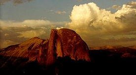
- The following figure shows the
famous Half Dome. How is this landscape related (if at all) to your answers
to questions 1 and 2? (For additional pictures of Half Dome,
visit the Virtual
Yosemite site.)
- Locate a saddle point, that is,
a point at which the terrain is level, but from which you can go either up
or down, depending on the direction you go. Give the altitude at the point
on the terrain. What features on the map help you locate this point?
- What is the altitude at the shore
of Mirror Lake? If you hiked northeast from Mirror Lake along Tenaya Creek,
what would be the average slope of your path? Suppose there were a sign at
the start of the trail that told hikers “__% grade.” What number
would be in the blank?
- If you wanted to hike from Mirror
Lake to the saddle point you found in step 4, what route would you take? Describe
the trail as explicitly as you can, and describe any features of the terrain
that might make this hike difficult. (For views of Mirror
Lake, visit the Virtual
Yosemite site.)
|
CCP Home | Materials | Multivariable
Calculus | Module Contents | Back
| Forward |